life has been manageable again so here goes....
this past week saw torrential downpour in southern california. while the rain is usually a welcome respite for drought plagued california, i hate it when it rains. there are many reasons to cite - from drivers who insist on driving fast so they can splash pedestrians and/or fellow motorists to looking like a wet dog.
however, i do like the day after. especially for angelenos, the day after means the smog has been washed away, albeit temporarily. it also means great views of the freshly snow-capped mountains. perfect time to hike.
this time, we chose sandstone peak near the border of los angeles and ventura counties off pacific coast highway.
this time, we chose sandstone peak near the border of los angeles and ventura counties off pacific coast highway.
to get there, from the pacific coast highway, turn onto yerba buena road (right next to neptune's restaurant) and follow it for a few miles. once you pass circle x ranch, go about maybe .2 miles more. you will then see this sign:


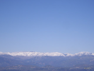
the snow capped mountains in the distance were stunning.


finally, at the top of mt. allen (aka sandstone peak). sure enough, the views were stunning and the air so crisp and clean.


turn onto the dirt road, which will lead to a parking lot. the trailhead starts here:

when we got there, the trail was, remarkably, not as muddy as one would expect after a week-long continuous pounding rain.


the snow capped mountains in the distance were stunning.


the lushness was also remarkable. who knew urban sprawl was just around the corner?


finally, we were almost to the top. while 3111 feet may not be that high, put in perspective, the tallest peak in the entire united kingdom is only about 4000 something feet.


finally, at the top of mt. allen (aka sandstone peak). sure enough, the views were stunning and the air so crisp and clean.

the compass in the picture below was on top of the mt. allen sign i was hanging on to in the picture above. the compass points to the "true north," which i found interesting because, if i didn't know better, it looked like it was pointing northeast.

after a leisurely two hour hike (3 miles roundtrip), we were famished and below was my salmon and egg scramble at the 17th street cafe.


